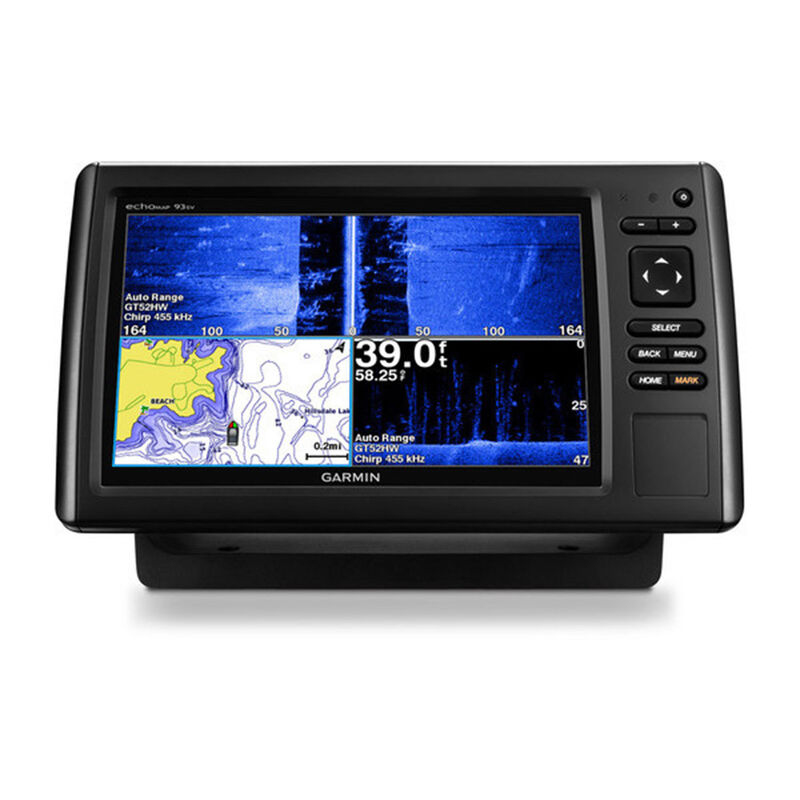
echoMAP CHIRP 93sv Fishfinder/Chartplotter with CHIRP SideVü/ClearVü/ Transducer and LakeVü HD Maps
Clearance offer reflects an additional 50% off the lowest price for in-store pick up only.
PLUS Plan includes:
- Wear and Tear Coverage
- Power Surge Protection
- Exchange for products under $400
- Onboard service on products over $750
- Up to 5 years of total coverage
PLUS plan goes into effect with purchase; no registration required. Purchase online, in stores or call 1 (800) 262-8464.
It’s time you started fishing with the power of CHIRP sonar. The easy-to-install, easy-to-use 9-inch echoMAP CHIRP 93sv includes transducer for high wide CHIRP sonar and Garmin CHIRP SideVü and Garmin CHIRP DownVü, the clearest scanning sonars on the water. It supports Panoptix sonar and includes preloaded Quickdraw Contours software to instantly create your own HD maps with 1-foot contours as you fish. Internal 5 Hz GPS updates position and heading 5 times per second. It provides NMEA 2000® support for engine data, sensors, autopilots and more. Cords plug directly into the mount, allowing you to quickly install and remove your device from power and mount. Transom and trolling motor mounts included.
- 9-inch color display with keypad control
- Includes GT52-TM transducer with high wide CHIRP, 250 W and CHIRP DownVü/SideVü, 455/800 and 350 W transducer
- Panoptix™ all-seeing sonar support (transducer not included)
- Preloaded LakeVü HD maps cover 17,000 total lakes, of which 13,000 are HD lakes with 1-foot contours shore to shore
- Includes Quickdraw Contours custom HD map creation software
The Garmin CHIRP Difference
The built-in sonar capabilities of echoMAP 93sv include CHIRP sonar, the most sophisticated sonar technology available for the fishing and boating public. CHIRP sonar provides amazingly clear target separation and definition because it puts even more energy onto the target than traditional sonar. It also includes sonar-recording capability that coordinates the timing of the sonar return with your boat's position and saves digital information for playback on a computer using HomePort™ planning software. Use the user data sharing cable to share waypoints and routes between multiple devices.
Clearest Scanning Sonar on the Water
Garmin CHIRP DownVü and CHIRP SideVü scanning sonars give you nearly photographic images of what’s below and to the sides of your boat. You clearly see structure, submerged objects and fish. Also supports Minn Kota® and MotorGuide® trolling motors with integrated transducers.
Preloaded LakeVü HD Maps
These highly detailed freshwater maps include 17,000+ U.S. lakes, rivers and reservoirs (more than double the number of preloaded lakes of any competitor). That number also includes more than 13,000 HD lakes with 1-foot contours shoreline to shoreline (again, 2 times more than our competition). LakeVü HD gives you excellent detail of underwater features, plus Shallow Water Shading allows you to designate a minimum depth. It also shows interstates, highways, general roads and bridges, designated fishing areas, docks, boat ramps, marinas and campgrounds.
Create Your Own HD Maps
Quickdraw Contours is a free, easy-to-use software feature already installed on your echoMAP CHIRP 93sv. It instantly creates your own personalized HD fishing maps on screen with 1-foot contours. Tailor the maps as needed; you own them. Keep the data for yourself, or share it with Garmin or your friends. No special surveying expertise is required. You just fish while Quickdraw Contours creates maps. There’s no waiting around or sending your files away like other mapping software requires — your results appear instantly. Use with any Garmin Panoptix transducer, any HD-ID™ sonar, any CHIRP-enabled, Garmin DownVü transducer or NMEA 2000-compatible depth transducer. Have more than 1 sonar device installed onboard? Quickdraw Contours automatically selects the most capable sonar device to provide the very best results for you.
Heading and Position Refreshed 5 Times per Second
Fast, responsive 5 Hz GPS/GLONASS refreshes your position and heading 5 times each second to make your movement on the screen more fluid. Now it’s quick and easy to drop up to 5,000 accurate waypoints and find your way back to your secret fishing hot spots.
Add Panoptix LiveVü Forward Sonar
With LiveVü Forward your boat can be moving or stationary. Wherever your trolling motor is pointed, you will see live images of what is happening under the water. Watch your lure as it sinks, and see its depth and movement as you retrieve it. See it move in relationship to structures in the water. See fish swimming, reacting to your bait; if they attack, you’ll see and feel the hit. Once on the hook, watch the fight on your screen as it happens. With Panoptix LiveVü Forward, you can see it all come to life up to 100 feet away.
Take Your echoMAP with You
When you’re off the water, it’s easy to keep your echoMAP safe and secure. You don’t have to mess with plugging and unplugging wires from the unit because the cords plug directly into the mount. This allows you to quickly install and remove your echoMAP from power and the mount.
Upgrade with the Best Garmin Maps on the Water
A single microSD™ card slot provides expandable memory for accessory map purchases such as LakeVü HD Ultra, BlueChart® g2 or BlueChart® g2 Vision®. LakeVü HD Ultra adds high-resolution relief shading, Dynamic Lake Level, Depth Range Shading and more than 92 MaxDef lakes. LakeVü HD Ultra and BlueChart g2 Vision also provides exclusive Garmin Auto Guidance, a technology that directs you to your hot spots. Based on your boat’s specifications, Auto Guidance instantly creates a visual path you can follow to avoid shallow water and other charted obstructions.
Enhanced Auto Guidance
Just enter the location where you want to go and patented Garmin Auto Guidance technology instantly searches through relevant charts to create a safe, virtual pathway on the display that helps you avoid low bridges, shallow water and other charted obstructions en route.
With enhanced Version 2.0, you have access to more features and capabilities. You’re able to adjust the calculated Auto Guidance pathway by inserting “via” points at interim stops or landmarks along your desired route. You can easily review hazard points along your calculated path. And you can even engage your compatible Garmin autopilot to follow the Auto Guidance route, automatically. Other 2.0 enhancements give you the ability to calculate arrival times at any point on your route (great for timing arrivals to correspond with bridge openings and other time-critical events). Better still, you can now save your plotted Auto Guidance paths for future navigation by backing them up on an SD™ card with your BlueChart g2 Vision or LakeVü HD Ultra cartography⊃1;.
GPX Waypoints Transfer
If you have waypoints, tracks or frequently used routes stored on another manufacturer’s GPS product - or on a Garmin handheld device - now it’s easier than ever to transfer those items to your new Garmin chartplotter, via industry-standard GPX software formatting. GPX is an open standard format for GPS data exchange across platforms and applications. With this easy-to-use interface technology, Garmin has taken “no waypoint left behind” to a whole new level of trade-up convenience.
Multiple Depth Range Shading
Designate up to 10 different depth ranges each with its own color. Makes it easier to view target depths at a glance.
Commission Autopilot from Chartplotter
To make commissioning easier and more convenient, you can handle the entire autopilot commissioning process from your chartplotter screen.
FUSION-Link Entertainment System
Enjoy the ability to control all compatible FUSION-Link-enabled audio systems directly from your compatible chartplotter display.
Special Sailing Features
Supported SailAssist features include laylines, enhanced wind rose, heading and course-over-ground lines and true wind data fields. Gauge displays are designed to provide important, need-to-know information at a glance, including true and apparent wind angle, set and drift, true or apparent wind speed, horizontal graphs and a data bar with customizable data fields. To help you gain a wind-maximizing competitive edge, your chartplotter features a pre-race guidance page that shows your virtual starting line, along with data fields showing laylines, time to burn before the start and a race timer.
⊃1;BlueChart g2 Vision or LakeVü HD Ultra SD card is required for this technology.
Transducer Options:
You may want to consider these transducer options, sold separately. Depending on the style of the transducer, you'll get depth, speed and/or temperature readings.
| Transducer Type: CHIRP | Reading(s) | Power | Depth | Material | Model |
|---|---|---|---|---|---|
| GT20-TM Traditional/ClearVu Transom Mount (4 pin) | Depth/Temp | 500W | 1,900' Traditional 750' ClearVu | Plastic | 17492372 |
| GT21-TM Traditional/ClearVu Transom Mount (8 pin)(Primary) | Depth/Temp | 600W Traditional 500W ClearVu | 1,500' Traditional 1,000' ClearVu | Plastic | 17596297 |
| GT21-TH Traditional/ClearVu Thru-Hull (8 pin)(Primary) | Depth/Temp | 600W Traditional 500W ClearVu | 1,500' Traditional 1,000' ClearVu | Plastic | 17596305 |
| GT40-TM Traditional/ClearVU/SideVu Transom Mount (12 pin) | Depth/Temp | 500W Traditional 500W CV/SV |
1,900' Traditional (900' Saltwater) 750' ClearVu; 500' SideVu |
Plastic/Stainless Steel | 17596347 |
| GT41-TM Traditional/ClearVU/SideVu Transom Mount (12 pin) | Depth/Temp | 600W Traditional 500W CV/SV |
1,500' Traditional 1000' ClearVu; 750' SideVu |
Plastic/Stainless Steel | 17596354 |
| GT41-TH Traditional/ClearVu/SidVu Thru-Hull (12 pin) | Depth/Temp | 600W Traditional 500W CV/SV |
1,500' Traditional 1000' ClearVu; 750' SideVu |
Plastic/Stainless Steel | 17596362 |
| GT41-THP Traditional/ClearVu/SidVu Thru-Hull Pair (12 pin) | Depth/Temp | 600W Traditional 500 W CV/SV |
1,500' Traditional 1000' ClearVu; 750' SideVu |
Plastic/Stainless Steel | 17596370 |


