#4 Lewes Canal - Rehoboth Bay
Clearance
$15.88
Price reduced from
$25.99
to
Model #
15852957
Mfg #
#4
Clearance offer reflects an additional 50% off the lowest price for in-store pick up only.
Quantity not available. Please adjust.
Temporarily Out of Stock
Thank you!
We'll let you know when it's back in stock.
-
+
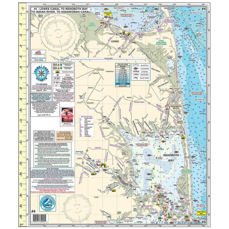
Home Port Chart #4 includes Roosevelt Inlet, Cape Henlopen, Rehoboth Beach, Dewey Beach, Delaware Seashore State Park, Long Neck,Indian River Inlet, and Bethany Beach. #4 shows Lewes and Rehoboth Canal, Rehoboth Bay, Love Creek, Shell Landing Cove, Masseys Ditch, Bakers Channel, Little Ditch, Indian River Bay and Indian River to Millsboro, DE, Pepper Creek, and White Creek to Bethany Beach and Ocean View. Home Port Chart #4 highlights: Depth Contours, Fishing "Hot Spots", Buoys and Daymarkers with on site GPS coordinates. Various DE State Regulations for Blue Crabs, licenses, permits and stamps, USCG phone numbers, and a 21 inch ruler are included in the body of the chart. It is laminated to assure a full season of waterproof protection.
Cartography
Lewes DE
,
Roosevelt Inlet
,
Lewes and Rehoboth Canal
,
Rehoboth Bay
,
Indian River Bay
,
Indian River/White Creek
,
Bethany Beach
Features
Fishing
,
Double Sided
,
Waterproof
Region
Atlantic Coast
,
Inland Waterway
,
Indian River Inlet
States
Delaware


