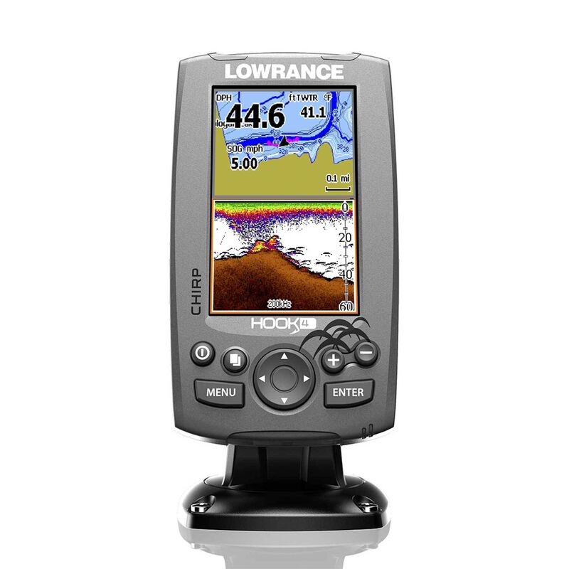
Hook-4 Fishfinder/Chartplotter with Mid/High CHIRP and DownScan™ Imaging with Navionics + Cartography


PLUS Plan includes:
- Wear and Tear Coverage
- Power Surge Protection
- Exchange for products under $400
- Onboard service on products over $750
- Up to 5 years of total coverage
PLUS plan goes into effect with purchase; no registration required. Purchase online, in stores or call 1 (800) 262-8464.
Frequently Bought Together


Top-of-the-line sonar technologies provide the best possible view of the environment beneath your boat.
Both CHIRP and Scanning Sonar: It’s got both CHIRP and DownScan Imaging™ built in, so you get the clearest view of fish, structure and the bottom. CHIRP provides more definition and better target separation than traditional sonar, and DownScan Imaging™ provides a nearly photographic image of what’s down below. Enhanced sonar sensitivity, excellent target separation and superior noise rejection make seeing baitfish and gamefish targets easier. Full color LED-backlit displays are bright and clear in all lighting conditions, and all functions are controlled and accessed via a simple keypad.
Basemap with detailed lakes and rivers: A detailed World Reference basemap featuring more than 3,000 US lakes and rivers and coastal contours to 1,000'. You can also add a wide variety of detailed charts with the microSD card slot. If you've been waiting for lower prices on top-of-the-line technology, your wait is over.
Additional Cartography: Navionics+™ Cartography makes lakes and coastlines in the U.S. and Canada crystal clear using high-definition 1-foot bathymetry. You can make your own maps and share cartography with the Navionics+ community, create sonar maps and use Dock-to-Dock autorouting. One year of daily updates and advanced features are included.
Key Features
- CHIRP Sonar plus DownScan Imaging™: the power of today's leading fishfinder technologies combined to provide the best possible view beneath your boat
- DownScan Overlay™ technology overlays DownScan Imaging onto CHIRP Sonar
- Advanced Signal Processing (ASP) reduces the need to manually adjust settings to see fish, structure and bottom detail more clearly
- TrackBack™ to review recorded sonar history including structure, transitions or fish targets, then pinpoint locations with a waypoint
- Internal GPS antenna: Highly accurate, built-in 10Hz GPS antenna
- Convenient Page selector menu with quick access to all features using one-thumb operation
- Multi-Window Display lets you quickly choose from pre-set page layouts - including a three-panel view
- microSD card slot for adding maps. Use your Insight Genesis™ custom maps created from your own sonar logs or compatible maps. Lake Insight® and Nautic Insight® PRO, Navionics® +, C-MAP MAX-N, Fishing Hot Spots® PRO, & Insight Genesis are all compatible with this technology.
What’s in the Box
- Hook-4 Chartplotter/Fishfinder
- Dual-frequency Skimmer HDI transducer with temperature
- Power cable
- Documentation pack
- Fuse holder (ATC blade)
- Fuse
- Quality Lowrance protective cover
- Nautic Insight Pro Map microSD card
Specifications
- Display Type: 16-bit color
- Backlight: LED (11 levels)
- Screen Size: 4.3” diagonal
- Screen Resolution: 480 x 272
- Transducer: Dual-frequency Skimmer HDI transducer with temperature
- Frequency: Mid/High CHIRP 83/200kHz, DownScan™ 455/800kHz
- Power Requirements: 12V DC
- Transmit Power: 500W (RMS)
- Dimensions: 3 13/16”W x 6 5/8”H x 2 3/16”D
- Power Requirement: 12V DC
- Voltage Input: 10 to 17V
- Amperage: Typical: 1.1A
- Fuse: 3A
- Waterproof Rating: IPX7
- Warranty: One year
Optional Accessories (Sold Separately)
| Accessories | Model |
|---|---|
| XT-20BL-20 foot extension cable | 11259322 |
| 7 pin Blue Connector to Bare Wires | 14706568 |
| ST-TBL Speed Temp Sensor | 14272777 |


