a75 Multi-Function Display with Wi-Fi and US LightHouse Vector Charts
Clearance offer reflects an additional 50% off the lowest price for in-store pick up only.
PLUS Plan includes:
- Wear and Tear Coverage
- Power Surge Protection
- Exchange for products under $400
- Onboard service on products over $750
- Up to 5 years of total coverage
PLUS plan goes into effect with purchase; no registration required. Purchase online, in stores or call 1 (800) 262-8464.
Frequently Bought Together


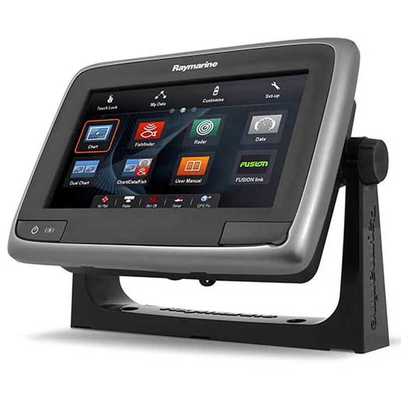
Swipe, touch and navigate—the a-Series brings full touchscreen simplicity to boaters looking for a powerful Chartplotter/Multi-Function Display with extensive add-on options. This 7" diagonal, 800 x 480 pixel multi-function display features Raymarine’s intuitive LightHouse II user interface, powered by a fast dual core processor with an additional graphics coprocessor. The super bright display is LED-backlit and optically-bonded so you will never have visibility issues, even in the brightest sunlight.
Wi-Fi Connectivity: We live in a mobile world, and that is why Raymarine has designed innovative connectivity features into the new a-Series displays. This a75 display is equipped with built-in Wi-fi for streaming to Apple iPhones or iPads. Simply download the RayViewer app from the Apple store and transform your iPhone or iPad into Raymarine repeater. View charts, radar, even thermal night vision right from anywhere onboard. Use built in Wi-Fi to synchronize waypoints and routes with your SmartPhone running Navionics Mobile apps. Plan your next voyage on your iPhone or iPad.
Navigate with Freely Available NOAA Raster and Vector Charts: a-Series owners can now experience greater charting flexibility with the introduction of LightHouse Charts. These free charts are derived from NOAA charts and offer a simple solution for navigating U.S. coastal waters. LightHouse Charts are available in Raster or Vector formats.
Control your audio with Bluetooth or FUSION link. Full control of FUSION 700 Series Marine Stereos
- Display Type: LED backlit, sunlight-viewable touchscreen
- Screen Size: 7"dia
- Screen Resolution: 800 x 480 pixels
- Display Viewing Angle: 70° left/right/top, 45° bottom Included
- Cartography: US LightHouse Vector charts
- Optional Cartography: Navionics Silver, Gold or Platinum PLUS
- Dimensions: 6 7/16"W x 5 11/16"H x 2 3/4"D
- Data Interface: Raynet Ethernet, SeaTalkng, NMEA 2000 (optional adapter), Wi-Fi, Bluetooth
- Receiver Type: 50-channel internal GPS
- Voltage: 12V (10.2-15.6V DC)
- Included Accessories: Flush-mount kit, trunnion bracket, silicone-rubber sun cover, power/data/video cable
- Waterproof Rating: IPX6, IPX7
- Warranty: Three years (with product registration)


