Types of Electronic Charts
Electronic charts are digital versions of traditional government-issued paper charts, and the underlying data used to make them comes from sources such as NOAA, Canadian Hydrographic Service and other official hydrographic offices. They can be displayed three ways: on a chartplotter, smartphone or computer. Waterproof chartplotters are the favored technology for boats smaller than 40-50 feet. A tablet, laptop or desktop PC is a common choice on larger craft, where a pilothouse provides a drier and shaded environment for a delicate, non-waterproof computer.
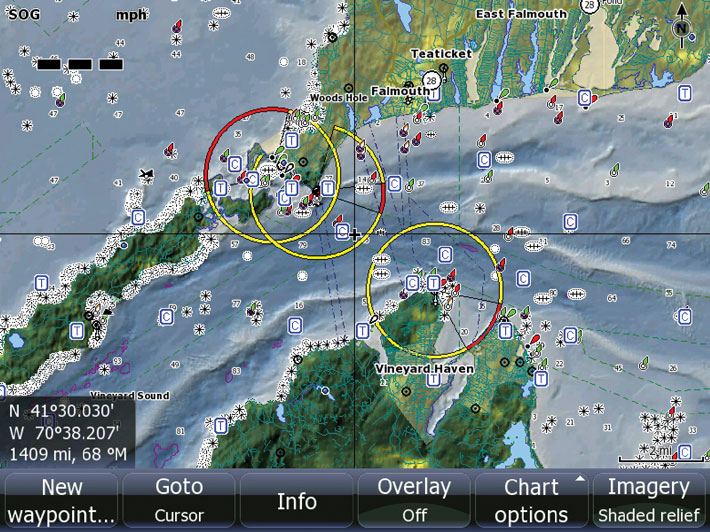
Electronic charts simplify navigation tremendously. They show your location in real time on a dynamic map, allow you to plan routes, display depth contours and navigation aids, and can integrate with GPS, AIS, radar and autopilot systems. However, prudent mariners still carry paper charts or other backup navigation resources because electronic systems can fail from power loss, water intrusion, software issues or hardware damage.
- Types of Electronic Charts
- Raster Charts vs. Vector Charts
- Chartplotter, Tablet or Laptop?
- Selecting the Right Coverage Area
- Chart Selection and Compatibility
- Electronic Chart Features to Compare
- Using a Laptop for Navigation
- Update Your Electronic Charts
- Why You Still Need Backup Navigation
- Common Electronic Chart Mistakes
- Electronic Chart FAQs
Electronic charts are formatted two ways: raster scanned charts and vector charts. Both can be accurate and useful, but they display information differently and have different strengths depending on how you navigate.
Raster Charts vs. Vector Charts
Raster scanned charts, like those from Maptech, are direct video images of paper charts. They are faithful copies of the paper versions, with all the familiar symbols, soundings and cartographic detail displayed in the same visual style as a printed chart.
Vector charts, like products from Garmin, Navionics and C-MAP, transform chart information into coordinate-based data files. Information is placed into layers in the memory of the machine. You can filter out layers you do not need at the moment and see only what is needed. The data is compressed to take up less space, icons and labels can display in a heads-up orientation, and object-oriented features can provide additional information when selected with a cursor.
| Chart Type | Strengths | Considerations |
|---|---|---|
| Raster Charts | Look like traditional paper charts; familiar to experienced navigators; preserve original chart appearance. | Less flexible when zooming; labels and symbols may not reorient; larger file sizes. |
| Vector Charts | Layered data, selectable objects, cleaner zooming, smaller files and improved chartplotter integration. | Chart appearance varies by brand and settings; over-filtering layers can hide important information. |
Most modern recreational chartplotters use vector charts because they integrate well with GPS, route planning, depth shading, AIS targets, radar overlays and other electronic navigation features. Raster charts remain useful for mariners who prefer the look and context of paper charts.
Chartplotter, Tablet or Laptop?
The best display platform depends on your boat, navigation style and operating environment.
Chartplotters
A dedicated chartplotter is the most practical primary navigation display for most recreational boats. Chartplotters are designed for sunlight visibility, water resistance, vibration, marine power systems and integration with GPS, sonar, radar, AIS and autopilot equipment.
Chartplotters are especially valuable on open boats, center consoles, sailboats and smaller cruisers where equipment may be exposed to spray and direct sun.
Tablets and Smartphones
Tablets and smartphones are convenient for planning routes, checking charts from the cockpit and providing a secondary navigation reference. Many apps offer strong charting features, but consumer devices have limitations. They may overheat in direct sun, become hard to read in glare, lose battery power quickly, lack waterproofing and depend on internal GPS or wireless connectivity.
A tablet can be a useful backup or planning tool, but it should not be the only navigation source for serious cruising or offshore boating.
Laptops and PCs
A laptop or onboard PC is a common choice on larger vessels where a pilothouse provides a dry, shaded environment. Computers offer large screens, powerful navigation software, route planning tools, weather overlays and storage for large chart libraries. They are less practical in exposed cockpits and should be protected from water, heat, shock and power interruptions.
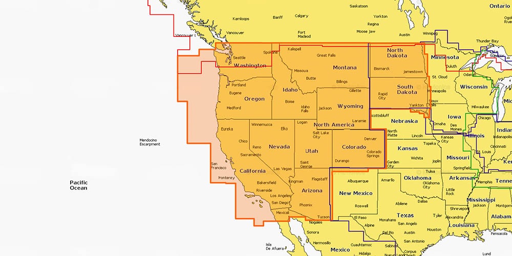
Selecting the Right Coverage Area
Electronic charts for chartplotters often come on microSD memory cards or are downloaded through the chart provider’s software or app. Because memory and licensing are tied to geography, you will need to choose the correct coverage area for where you use your boat.
Coverage areas may include coastal regions, inland lakes, river systems, country-specific waters or large offshore regions. Before buying, confirm that your usual cruising grounds, launch areas, destination harbors and backup ports are included. If you regularly trailer your boat or cruise across regions, you may need more than one chart card or a broader subscription package.
Coverage Questions to Ask
- Does the chart cover my home waters?
- Does it include my destination ports and alternate harbors?
- Does it include inland lakes or only coastal waters?
- Does it include detailed marina, inlet and approach data?
- Will I need coverage for another country or island group?
- How often can the chart be updated?
Chart Selection and Compatibility
You have to select the brand of chart and generation of product that fits the chartplotter you own or are considering. For example, Garmin units operate with Garmin chart products. Many Raymarine, Navico and Humminbird plotters support Navionics or C-MAP options depending on model and generation.
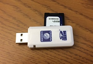
Update your charts, step one: To update a Navionics chart using their Freshest Data program, you remove the MicroSD card from your multi-function display, and place it in this card reader.
Before purchasing electronic charts, confirm:
- Your chartplotter brand and model number
- Supported chart format
- Compatible card type or download method
- Maximum card size or software version requirements
- Whether your device requires a firmware update
- Whether advanced features require a premium chart tier
Chart compatibility is not universal. A card that works in one brand or generation of chartplotter may not work in another. Always verify compatibility before buying or updating a chart card.
Electronic Chart Features to Compare
Modern electronic charts do more than show shorelines and depth numbers. Depending on brand and subscription tier, they can include advanced features that make route planning, fishing, cruising and harbor entry easier.
- Depth contours: High-resolution contour lines help anglers identify drop-offs, ledges and structure.
- Shallow water shading: Highlights shoal areas or user-defined depth ranges.
- Auto-routing: Suggests routes based on chart data, vessel draft and navigation hazards.
- Satellite imagery: Helps identify marinas, channels, anchorages and shoreline features.
- Sonar chart layers: Crowd-sourced or enhanced bathymetric data for improved bottom detail.
- Marina and services data: Fuel docks, slips, repairs, ramps, restaurants and contact information.
- Community edits: User-submitted local knowledge, hazard updates or anchorage notes.
- Tides and currents: Integrated predictions for route planning and anchoring decisions.
- AIS and radar overlays: When supported by your electronics, charts can display surrounding vessel traffic and radar returns.
Choose features based on how you actually boat. An offshore cruiser may prioritize official updates and long-range coverage. A fisherman may care more about detailed contours and bottom structure. A day boater may want easy harbor navigation, ramps and marina data.
Using a Laptop for Navigation
It is not surprising that a PC has become a powerful navigational tool, especially for big boat and offshore navigation. Navigating with a laptop computer allows you to apply its processor, memory and storage capacity to run software with a wide range of capabilities.
Laptop navigation can support route planning, weather overlays, offshore passage planning, log keeping and large chart libraries. On larger vessels, a laptop or dedicated onboard computer may function alongside a chartplotter rather than replacing it.
Electronic Navigational Chart Downloads
Recent changes in the costs of domestic charts have made it much more cost-effective to have the U.S. coverage that you need, assuming you are navigating with a PC and compatible software. Mariners can download current vector or raster charts from NOAA and cruise American waters. The same is not always true for international destinations, since public domain chart availability varies by country.
If you use a laptop, protect it with a stable power supply, backup battery, secure mounting, dry environment and redundant navigation source. A laptop is powerful but not rugged in the same way as a waterproof chartplotter.
Update Your Electronic Charts!
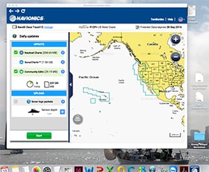
Update your charts, step two: Plug the card reader into your computer, log onto the Navionics site, and refresh the chart with Notices To Mariners, Community Edits, and crowd-sourced Sonar Charts.
Most boaters carry official NOAA paper charts and also use electronic navigation, but many recreational boaters do not keep their e-charts current by updating them regularly with accumulated weekly Local Notices to Mariners (LNMs), published by U.S. Coast Guard districts. These LNMs provide critical safety information about sunken vessels, shifting shoals, buoy changes, missing navigational aids and other safety hazards.
While paper charts may become dog-eared and smudged, alerting you that it is time to purchase a replacement, your out-of-date electronic chart will look brand new. That is one of the greatest risks of electronic navigation: old data can appear current on screen.
Chart update programs from brands such as Navionics, Garmin and C-MAP allow boaters to refresh chart cards or subscriptions with corrected data, community edits, sonar chart layers and notices. Update frequency depends on the provider and subscription status, but checking for updates before the season and before long trips is a smart habit.
When to Update Electronic Charts
- Before the start of each boating season
- Before a long cruise or offshore passage
- Before entering unfamiliar waters
- After major storms or hurricanes that may shift shoals or markers
- When a chart provider announces new data
- When buying a used boat or used chartplotter
Why You Still Need Backup Navigation
Electronic navigation is powerful, but it should not be the only way you know where you are. Chartplotters, tablets, phones and laptops can fail. Batteries die, screens crack, software freezes, GPS antennas lose signal and water can damage electronics.
Carry backups appropriate for your boating area. That may include paper charts, a handheld GPS, a compass, a second mobile device with offline charts, printed route notes or a cruising guide. For offshore and remote cruising, redundancy is not optional; it is part of basic seamanship.
Smart Backup Navigation Tools
- Updated paper charts or print-on-demand charts
- Handheld GPS with spare batteries
- Magnetic compass
- Offline chart app on a second device
- Cruising guide or harbor guide
- Written route plan with waypoints and bearings
- Depth sounder awareness and visual piloting skills
Common Electronic Chart Mistakes
- Using outdated charts: Old electronic charts may miss buoy changes, shoaling, wrecks or updated harbor information.
- Assuming auto-routing is perfect: Automatic routes must still be reviewed by the operator for draft, bridge clearance, restricted areas and hazards.
- Relying only on a phone: Phones are useful backups but can overheat, lose battery power or become unreadable in sunlight.
- Over-filtering chart layers: Turning off too many details can hide important navigation aids, depth information or hazards.
- Buying the wrong coverage area: Always confirm that your exact boating region is included before purchasing.
- Ignoring device compatibility: Chart cards and downloads must match the chartplotter brand, model and supported format.
- Failing to cross-check position: Use visual navigation, depth soundings, compass bearings and chart awareness to confirm what the screen shows.
Browse All Marine Electronics & Navigation Gear
- Chartplotters, GPS units, radar systems, and integrated navigation displays
- Sonar, CHIRP, downscan, and fish-finding electronics
- Marine stereos, speakers, amplifiers, and audio accessories
- VHF radios, AIS, satellite communication equipment
- Autopilot systems and steering control components
- Wind, depth, speed, and multifunction instruments
- Marine binoculars for navigation and low-light use
- Thermal and night-vision devices for situational awareness
- Onboard monitoring and security systems
- Magnetic and electronic compasses
- Paper and electronic navigation charts
- Regional cruising and harbor guides
- Traditional navigation plotting tools
Electronic Chart FAQs
What are electronic charts?
Electronic charts are digital nautical charts used on chartplotters, tablets, smartphones and computers. They display navigation information such as shorelines, depth contours, aids to navigation, hazards, routes and position data when connected to GPS.
What is the difference between raster and vector charts?
Raster charts are scanned images of traditional paper charts, so they look familiar to mariners who use paper navigation. Vector charts store chart information as layered data, allowing users to zoom, select objects, filter information and integrate chart details with modern electronics.
Can I use a tablet instead of a chartplotter?
A tablet can be a useful planning tool or backup navigation device, but a dedicated marine chartplotter is usually better as a primary navigation display because it is built for sunlight visibility, water resistance, marine power and integration with other onboard systems.
How often should I update my electronic charts?
Update electronic charts before each boating season, before long trips and before navigating unfamiliar waters. You should also check for updates after major storms, changes to navigation aids or chart provider data releases.
Do I still need paper charts if I have electronic charts?
Prudent mariners carry backup navigation resources because electronic systems can fail. Paper charts, a compass, a handheld GPS and offline chart apps can provide redundancy if a chartplotter, tablet or laptop stops working.
How do I choose the right chart coverage area?
Choose coverage based on your home waters, destination ports, alternate harbors, inland or coastal needs and any regions you may trailer or cruise to. Confirm the exact coverage boundary before purchasing a chart card or subscription.
Are chart cards compatible with every chartplotter?
No. Chart cards and downloads must match the chartplotter brand, model and supported chart format. Always check compatibility before buying or updating electronic charts.
Can electronic charts route my boat automatically?
Some electronic charts include auto-routing features, but automatic routes must be reviewed carefully. The operator is still responsible for checking depth, draft, bridge clearance, hazards, restricted areas and local conditions.