HDS-7 Gen3 Fishfinder/Chartplotter with TotalScan™ Transducer and Insight USA Charts
PLUS Plan includes:
- Wear and Tear Coverage
- Power Surge Protection
- Exchange for products under $400
- Onboard service on products over $750
- Up to 5 years of total coverage
PLUS plan goes into effect with purchase; no registration required. Purchase online, in stores or call 1 (800) 262-8464.
Top-of-the-line sonar technologies provide the best possible view of the environment beneath your boat.
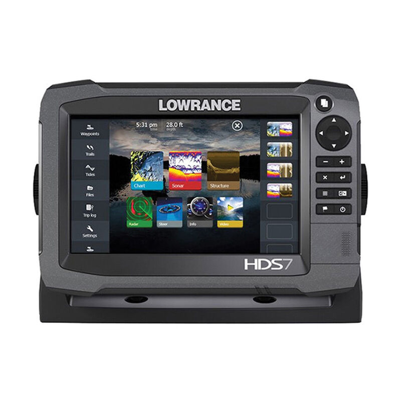
High Definition System (HDS) Gen3 combines a bright, multi-touch display and enhanced processor with high-tech fishfinder capabilities. It works with CHIRP Sonar, Broadband Sounder™, StructureScan® HD, DownScan Imaging™ and Trackback™ view. It comes with advanced navigation, an internal GPS and dual microSD-card slots. It's designed with an uncomplicated user interface, touch-plus-keypad operation and built-in wireless connectivity for your convenience.
FishReveal™ Smart Target Viewing: A massive leap forward in fish-finding technology, FishReveal makes it easier to see fish on DownScan Imaging™. Unlike traditional CHIRP views that provide strong fish targets, but lack refined structure detail, or DownScan Imaging that provides photo-like images of the bottom and structure details but shows fish targets as tiny dots -- FishReveal Smart Target Viewing blends the best data from both, eliminating the need for split-screen viewing and interpretation.
C-MAP Navigation Palette: C-MAP charts just got a major upgrade in readability that is most apparent near shore, where colors used for land, docks, anchorage areas, water, and channels are nicely differentiated and water contour lines are distinct. The new palette makes it easier to tell where the boat is in relation to a channel, navaid, ledges and drop-offs, or a point of land. The color scheme is also much easier on the eye.
Automatic Routing: Get faster and easier navigation with automatic route planning. This feature simplifies route creation by automatically plotting the shortest and safest course based on the boat's draft, beam
Both CHIRP and Scanning Sonar: It’s got both CHIRP and Scanning Sonar built in, so you get the clearest view of fish, structure and the underwater environment. CHIRP provides more definition and better target separation than traditional sonar, and Scanning Sonar provides a wide angle of detailed imagery from around your boat so your views aren't limited to down. Enhanced sonar sensitivity, excellent target separation and superior noise rejection make seeing baitfish and gamefish targets easier.
TotalScan™ Transducer: TotalScan™ matches proven Broadband Sounder and CHIRP Sonar with StructureScan® HD and DownScan ImagingTM technology — making it possible to target fish and search for fish-holding structure with the same transducer. The TotalScan™ transducer features multiple mounting options and is fully compatible with displays featuring integrated support for StructureScan® HD.
Key Features
- Simple To Use: Improved Lowrance interface with touchscreen or keypad option provides lightning-fast, fingertip access to all HDS features. This device boasts intuitive user-interface features like scrolling menus, cursor assist, snap-to setting markers and innovative preview panes with quick-touch slider bars.
- HD CHIRP Sonar and StructureScan®: The power of today's leading fishfinder technologies combined to provide the best possible view both below and to the side of your boat.
- Cohesive Connectivity: It's built to wirelessly connect with the Lowrance GoFree App and other onboard devices. You can even view and control select HDS Gen3 displays wirelessly using supported tablets and smartphones.
- Plug-and-Play Design: Compatible with Lowrance performance modules such as Broadband Radar, SonicHub Marine Audio, SiriusXM Marine Weather and audio, Class B AIS and DSC VHF. What's more, it works with industry-leading technologies like SmartSteer control for MotorGuide PinpointGPS and the Lowrance Outboard Pilot.
- Insight Genesis™ Personalized Maps: Make your own maps using recorded sonar logs! You can upload data to your Insight Genesis account, view secure custom chart detail online, add optional vegetation or bottom-hardness overlays, download information to an SD card and use all of this on the water. You can even share your maps with the Insight Genesis Social Map community!
- Multi-view Capabilities: View two charts simultaneously, in 2D or 3D perspective view, and use independent control, range and overlay capabilities.
- Get the Most out of Your Maps: With one map card purchase, you can view it on all Ethernet networked HDS Gen3, HDS Gen2 or Gen2 Touch chartplotter displays. Lake Insight® and Nautic Insight® PRO, Navionics® +, C-MAP MAX-N, Fishing Hot Spots® PRO, & Insight Genesis are all compatible with this technology.
What’s in the Box
- HDS Gen3 display
- Suncover
- Bracket
- Knobs
- Fasteners (4 x 6G x 1.5 panhead PH1)
- Power cable
- Fuse holder (ATC blade)
- Fuse (3 amp)
- Caps (3x for HDS7 4x for HDS9/12 - for ethernet, NMEA 2000, StructureScan)
- TotalScan™ Transducer and hardware
- Documentation pack (Operator & Installation manual, Quick guide, warranty card)
Specifications
- Data Interface: NMEA 2000/0183; Ethernet Port x2; microSD card slot x2; Wireless (802.11b/g/n); Video input (Composite video RCA)
- Receiver Type: Internal 10Hz ultra-high-sensitivity WAAS + EGNOS + MSAS
- Included Cartography: Insight USA
- Optional Cartography: Insight Genesis, Lake Insight™, Nautic Insight™ PRO and HD, Insight™ TOPO, Navionics®+, Navionics Platinum+,Gold, HotMaps® Premium, Fishing Hotspots® PRO and Jeppessen C-MAP MAX-N+
- Display Type: Color TFT LCD
- Backlight: >1200 nits
- Screen Size: 7” diagonal
- Screen Resolution: 800 x 480
- Touchscreen: Multi-touch P-CAP
- Viewing Angle: L/R: 60°/60°; T/B: 40°/60°
- Transducer: TotalScan
- Transmit Power: 500W (RMS)
- Power Requirement: 12V DC
- Voltage Input: 10.8 to 17V
- Power Consumption: Full brightness: 15.6W; Low power standby: <650mA
- Operating Temperature: 5°-131°F
- Waterproof Rating: IPX7
- Warranty: One year


