
By Brian Gordon, West Marine
Reading buoys is one of the most practical and important skills in recreational boating — and one of the most commonly misunderstood. Most boaters learn the basic rule (red right returning) and stop there. But the full US aids-to-navigation system contains lateral markers, cardinal buoys, regulatory buoys, an entirely separate ICW overlay system, and a set of light patterns used for night navigation. Miss any of these and you can end up on the wrong side of a channel, inside a restricted zone, or confused at a junction where the rules appear to contradict themselves.
This guide covers how to read US buoys systematically — what to look for first, how to interpret each type, how the ICW system works, and how to navigate by buoy lights after dark. The 49-type reference list covers the full range of buoys you may encounter on both coastal and inland waters.
- How the US Aids to Navigation System Works
- Red Right Returning: The Rule and What It Actually Means
- Buoy Shapes and What They Tell You
- Cardinal Buoys: Navigating Around Hazards
- Regulatory and Warning Buoys
- The Intracoastal Waterway System
- Night Navigation: Reading Buoy Lights
- When Buoys Are Missing or Off-Station
- Complete Buoy Reference: 49 Types
- Buoys Offered by West Marine
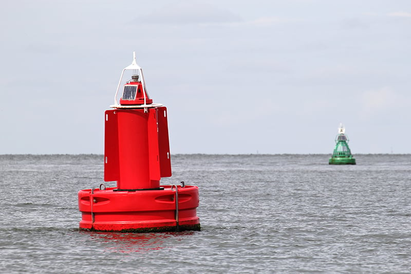 Channel marker buoys.
How the US Aids to Navigation System Works
The United States uses the IALA-B buoyage system, also used in the Americas, Japan, Korea, and the Philippines. The rest of the world — Europe, Africa, Australia, and most of Asia — uses IALA-A, where the lateral colors are reversed. This matters if you ever sail internationally: what was on your right coming into a US port will be on your left in a European port.
The US system has five categories of marks, each with a distinct purpose:
- Lateral marks define the sides of a navigable channel. Red and green, numbered, governed by Red Right Returning in the US.
- Cardinal marks indicate the direction of safe water relative to a specific hazard. Used offshore and where lateral marks are not practical.
- Isolated danger marks sit directly over a hazard surrounded by safe water on all sides. Black with red bands and two black spherical top marks.
- Safe water marks indicate navigable water clear of hazards — safe on all sides. Red and white vertically striped.
- Special marks indicate anything outside the above categories: pipelines, restricted areas, traffic separation, research equipment. Always yellow.
Separately, regulatory and warning buoys (white with orange markings) communicate local rules and hazards on US inland waters. They are not part of the IALA system.
Red Right Returning: The Rule and What It Actually Means
The core rule of US lateral navigation is Red Right Returning: when returning from the sea, keep red buoys on your starboard (right) side. Green buoys go on your port (left) side.
The word “returning” is where most confusion starts. It does not mean returning home. It means returning from the sea — which translates to:
- On coastal waters: heading inland, into a bay, harbor, or inlet from the ocean
- On rivers: heading upstream, away from the river's mouth
- On the East Coast ICW: heading south (clockwise along the US coastline)
- On the Gulf Coast ICW: heading west (continuing clockwise)
- On the West Coast: heading north from the Pacific
The numbers confirm your direction: red buoys have even numbers, green have odd numbers, and the numbers increase as you proceed in the returning direction. If you see red buoy 4 followed by red buoy 6, you are heading in the returning direction. If the numbers are decreasing, you are heading seaward and red should be on your left.
The rule does not change when a channel bends. If red should be on your right heading into a harbor, it stays on your right throughout that channel even if it turns 180 degrees back toward the sea. Color and number tell you which side of the channel you are on, not which compass direction you are heading.
Buoy Shapes and What They Tell You
In the US system, the shape of a lateral buoy reinforces its color — useful when distance, sun angle, or lighting makes color identification uncertain.
Red buoys (starboard side returning): nun buoys. A cylindrical body with a conical (pointed) top. Even when the red color is ambiguous, the pointed top identifies it as a starboard marker.
Green buoys (port side returning): can buoys. A cylindrical body with a flat top, like a tin can. The flat top identifies it as a port marker regardless of lighting.
This redundancy — color reinforced by shape reinforced by number parity — is intentional. At dawn, dusk, or in haze you may not be certain of color. Shape and number parity give you two independent checks. Lighted buoys add a fourth: red buoys display red lights, green buoys display green lights.
Cardinal Buoys: Navigating Around Hazards
Cardinal buoys are not lateral channel markers — they do not mark channel sides. They mark a specific hazard and tell you which direction from the buoy is safe to pass. A north cardinal buoy tells you safe water is to the north. Pass to the north of it. A south cardinal: pass to the south.
Cardinal buoys are yellow and black, with two conical top marks whose orientation indicates direction. The memory device is a clock face:
- North cardinal: Both points up (12 o’clock). Black on top, yellow below. Pass to the north. Light: continuous quick flashing.
- South cardinal: Both points down (6 o’clock). Yellow on top, black below. Pass to the south. Light: 6 quick flashes then a long flash.
- East cardinal: Points out, base to base (3 o’clock). Black top and bottom, yellow middle. Pass to the east. Light: 3 quick flashes.
- West cardinal: Points in, tip to tip (9 o’clock). Yellow top and bottom, black middle. Pass to the west. Light: 9 quick flashes.
Cardinal buoys are more common offshore than in US coastal channels, but you will encounter them around offshore hazards where there is no defined channel to mark laterally.
Regulatory and Warning Buoys
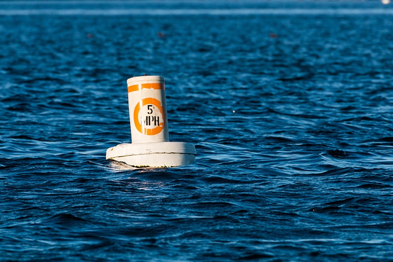 Speed limit buoy.
Regulatory and warning buoys are white with orange markings. They communicate local rules and hazards on US inland waters and are not part of the IALA system. The orange symbol shape tells you the category:
- Orange circle: A regulatory instruction you must obey — a speed limit, no-wake restriction, or other enforceable rule. The specific instruction appears inside or below the circle.
- Orange diamond: A hazard warning. Informational — it tells you a hazard exists nearby. The hazard type may be specified by text.
- Orange diamond with cross inside: Keep out. Entry prohibited in the marked area.
- Orange square: Information. Non-regulatory content such as marina location, distance, or local conditions.
These buoys are often deployed by state and local authorities rather than the Coast Guard. The color scheme is standardized nationally; the specific symbols and wording vary locally.
The Intracoastal Waterway System
The Intracoastal Waterway (ICW) runs 3,000 miles from Manasquan, New Jersey, along the Atlantic coast and through the Gulf of Mexico to Brownsville, Texas. It uses the same red-and-green lateral system as all US coastal waters, but with a critical overlay: yellow symbols on every ICW marker that identify it as part of the ICW and tell you which side to pass it on when following the ICW route.
The ICW’s “returning” direction is clockwise around the US coastline: south on the Atlantic, west on the Gulf. Red right returning still applies when following that direction. But the yellow symbols resolve the most confusing problem on the ICW: the waterway frequently intersects with other channels that run in the opposite direction, causing buoy colors and ICW direction to appear to conflict.
- Yellow triangle: Keep this mark on your starboard (right) side when following the ICW. Triangles to the right.
- Yellow square: Keep this mark on your port (left) side when following the ICW. Squares to the left.
- Yellow horizontal band: Identifies the mark as part of the ICW system but provides no lateral information about which side to pass.
The critical rule: when you see a yellow square or triangle, follow it, regardless of the underlying marker’s color or number. It is entirely normal to see a red triangular daymark (which the standard system says starboard) with a yellow square on it (which the ICW system says port). In this case, follow the yellow square. This is not an error — it is the system correctly handling a waterway intersection where the ICW and a crossing channel have opposite lateral significance.
A practical note from experienced ICW navigators: near certain waterway intersections (such as where the ICW crosses the Savannah River), the lateral buoyage switches sides multiple times in a short distance. At these junctions, the yellow symbols are your reliable guide. Look for the yellow triangles and squares on every marker and follow them, not the color.
Night Navigation: Reading Buoy Lights
Lighted buoys add a time dimension to the color and shape information available in daylight. At night, light color confirms buoy type and the flash pattern (called the light characteristic) identifies a specific buoy against the chart.
Light colors: Red lights mark starboard (red) buoys. Green lights mark port (green) buoys. White lights mark safe water marks and some regulatory marks. Yellow lights mark special purpose marks.
Common flash patterns:
- Fl (flashing): Single flash repeated at regular intervals, with darkness longer than light. The most common pattern on channel buoys. “Fl R 4s” means a red light flashing every 4 seconds.
- Iso (isophase): Equal periods of light and darkness.
- Oc (occulting): Light is on longer than it is off — the reverse of flashing.
- Q (quick): Rapid flashing, approximately 50–60 flashes per minute. Used on cardinal buoys. North cardinal: continuous quick flashing. East: 3 quick flashes. South: 6 quick flashes then a long flash. West: 9 quick flashes.
- Mo(A) (Morse Code A): Short-long flash sequence. Marks safe water (midchannel/landfall) buoys.
- Fl(2), Fl(3), etc.: Grouped flashing — two or three flashes in succession, then darkness, then repeat. Allows individual buoys to be distinguished from each other on busy waterways.
The flash period appears on your nautical chart next to the buoy symbol. Match what you observe on the water to the chart notation to confirm your position. The discipline at night is to not assume: a red flashing light could be a channel buoy or a fixed red light on a structure. Confirm the specific flash period against the chart before altering course.
When Buoys Are Missing or Off-Station
The USCG explicitly states in its regulations that buoy positions are not always reliable. Buoys are moved by vessel collisions, severe weather, strong current, and anchor fouling. A buoy may be hundreds of feet from its charted position, or missing entirely. A replacement buoy may have different characteristics than the permanent buoy shown on the chart.
- Never navigate solely by buoys. Use the chart as your primary reference and treat buoys as confirmation of your chart work, not a substitute for it.
- A missing buoy does not mean safe water. Slow down, navigate by chart and depth sounder, and treat the area as potentially hazardous until you are clear.
- If a buoy seems out of position, trust the chart. Assume the buoy has dragged off-station rather than that the chart is wrong. Verify your position by independent means before proceeding.
- In fog, do not use buoy sound signals as position fixes. Bell and whistle buoys generate sound from wave action. If a buoy has dragged, its sound may be coming from well off its charted position.
- Report discrepancies. Call the Coast Guard on VHF Channel 16 or file a report through the USCG Local Notice to Mariners. It helps other boaters and gets the situation corrected.
Complete Buoy Reference: 49 Types
The following reference covers the full range of buoys you may encounter on US and international waters. All lateral marks follow US IALA-B conventions.
Navigational Buoys
1. Lateral Buoys (Red & Green Channel Markers)
Description: Floating cylindrical (can) or conical (nun) buoys marking channel edges. In US IALA-B: red/even = starboard when returning; green/odd = port when returning.
Function: Marks the sides of a navigable channel. Red Right Returning.
2. Starboard-Hand Buoy (Red)
Description: Conical (nun-shaped) red buoy with an even number. Displays a red light when lighted.
Function: Marks the starboard (right) side of a channel when returning from sea. Keep on your right heading into port or upstream.
3. Port-Hand Buoy (Green)
Description: Cylindrical (can-shaped) green buoy with an odd number. Displays a green light when lighted.
Function: Marks the port (left) side of a channel when returning from sea. Keep on your left heading into port or upstream.
4. Preferred Channel Marker (Red & Green)
Description: Horizontally striped red and green buoy. Top color band indicates the preferred channel side.
Function: Marks a channel junction. The preferred (main) channel passes the buoy on the side of the top color band.
5. Safe Water Buoy (Red & White Striped)
Description: Vertically striped red and white buoy, spherical or pillar shape. May carry a single red spherical top mark. Displays Morse Code “A” (short-long) light when lighted.
Function: Marks safe navigable water clear of hazards on all sides — midchannel or offshore approach.
6. Isolated Danger Buoy (Black & Red Bands)
Description: Black buoy with one or more horizontal red bands and two black spherical top marks, placed over the hazard.
Function: Indicates a submerged hazard in otherwise safe water. Pass on either side with a wide berth.
7. Special Purpose Buoy (Yellow)
Description: Yellow cylindrical or pillar buoy. May carry a yellow X-shape top mark.
Function: Marks special designations: pipelines, cable crossings, traffic separation, restricted areas, research buoys. Specific purpose is indicated by text or symbols.
8. Cardinal Buoy (North, South, East, West)
Description: Yellow and black buoy with two conical top marks. Arrangement of colors and top mark orientation indicates safe direction. Uses quick-flash light patterns for night identification.
Function: Indicates safe direction relative to a hazard. Pass to the side named by the buoy’s compass direction.
Regulatory and Warning Buoys
9. No-Wake Buoy
Description: White cylindrical buoy with an orange circle containing a no-wake symbol.
Function: Marks areas requiring idle speed to prevent wake damage.
10. Speed Limit Buoy
Description: White buoy with an orange circle displaying a specific speed limit.
Function: Enforces a speed restriction in the marked area.
11. No-Entry Buoy
Description: White buoy with an orange diamond bearing a black slash or cross inside.
Function: Marks prohibited entry zones.
12. Hazard Buoy
Description: White buoy with an orange diamond. Hazard type may be described in text.
Function: Warns of a specific hazard nearby — shoal, rock, dam, or obstruction.
13. Swim Area Buoy
Description: White buoy with an orange circle or text marking a designated swimming zone.
Function: Marks swimming areas where boats must not enter.
14. Diver Down Buoy
Description: A red buoy with a white diagonal stripe (the international diver down flag: red background, white diagonal stripe from lower-left to upper-right), or a white buoy flown with this flag.
Function: Signals divers below the surface. Stay well clear and travel at idle speed in the vicinity.
15. Information Buoy
Description: White buoy with an orange square. Information appears inside or below the square.
Function: Provides non-regulatory information: marina locations, distances, local conditions.
16. Keep-Out Buoy
Description: White buoy with an orange diamond containing a cross.
Function: Marks areas where boat entry is prohibited for safety, environmental, or facility reasons.
17. Fishing Restriction Buoy
Description: Yellow buoy with a black fish symbol or text indicating fishing regulations.
Function: Marks areas where fishing is restricted or regulated.
18. Pipeline or Cable Buoy
Description: Yellow cylindrical or pillar buoy marking an underwater pipeline or cable.
Function: Marks submerged infrastructure to prevent anchoring damage.
Specialized Buoys for Waterways & Harbors
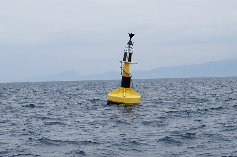 Weather buoy.
19. Anchorage Buoy
Description: Yellow or white buoy with a black anchor symbol.
Function: Marks designated anchorage areas in harbors and sheltered waters.
20. Security Zone Buoy
Description: Yellow or white buoy with black text marking security-sensitive zones.
Function: Marks restricted zones near government or military installations.
21. Quarantine Buoy
Description: Yellow buoy with a black “Q”.
Function: Marks areas where incoming vessels must undergo quarantine clearance before entering port.
22. Weather Buoy
Description: Large yellow buoy with meteorological instruments including anemometers, barometers, and wave sensors.
Function: Transmits real-time weather and sea state data for forecasting and maritime safety.
23. Scientific Buoy
Description: Yellow buoy with solar panels or antennas for environmental data collection.
Function: Collects long-term oceanographic data for scientific and environmental research.
24. Traffic Separation Buoy
Description: Red or green buoy marking vessel movement lanes in heavy-traffic areas.
Function: Guides vessels through busy waterways to reduce collision risk.
25. Dredging Buoy
Description: Yellow or red buoy marking active dredging or temporary channels.
Function: Directs vessels away from dredging work zones.
26. Ice Buoy
Description: White or yellow buoy marking safe passage through icy waters.
Function: Indicates ice-free channels during winter navigation.
27. Harbor Entrance Buoy
Description: Large red or green buoy at a harbor entrance, often with light or sound signal.
Function: Marks the safe entrance to a harbor for day and night navigation.
28. Pilot Boarding Buoy
Description: Yellow buoy at a designated pilot boarding area.
Function: Marks where harbor pilots transfer to incoming commercial vessels.
Buoys Used in Specific Water Activities
 Kayak trail buoy.
29. Race Course Buoy
Description: Inflatable or fixed bright-colored buoys marking a racing course.
Function: Defines the boundaries and turning marks of a race course.
30. Water Ski Buoy
Description: Small yellow or orange buoy marking water skiing areas or slalom courses.
Function: Designates areas for water skiing activities.
31. Rowing Lane Buoy
Description: Bright-colored cylindrical buoy marking rowing competition lanes.
Function: Defines lanes for rowing events and keeps other vessels out.
32. Kayak Trail Buoy
Description: Small white or green buoy on a designated kayaking route.
Function: Guides kayakers along established paddling trails.
33. Personal Watercraft (PWC) Buoy
Description: White or yellow buoy designating a personal watercraft zone.
Function: Marks areas designated for jet skis and similar craft, separated from other vessel traffic.
34. Event Marker Buoy
Description: Temporary inflatable buoy for marine events or competitions.
Function: Marks course boundaries or reference points for temporary marine events.
35. Artificial Reef Buoy
Description: White or yellow buoy marking an artificial reef.
Function: Marks artificial reef locations for divers and anglers.
36. Fish Habitat Buoy
Description: Yellow buoy with a black fish symbol marking a conservation zone.
Function: Marks zones protected for fish population and marine ecosystem management.
37. Seaplane Buoy
Description: White buoy marking a designated seaplane landing and takeoff area.
Function: Marks safe seaplane operating areas and warns boats to stay clear.
38. Floating Dock Buoy
Description: White or yellow buoy marking floating docks or platforms.
Function: Marks floating dock locations to prevent vessel collision.
39. Mooring Buoy (White with Blue Band)
Description: White spherical or cylindrical buoy with a single blue stripe and a pick-up pendant at the top.
Function: Provides a pre-set mooring point where boats can tie up without anchoring. Common in coral reef areas and marine sanctuaries where anchor damage is prohibited.
Deep Water & Offshore Buoys
40. Oceanographic Buoy
Description: Large orange, yellow, or red buoy with long-term environmental monitoring instruments.
Function: Collects and transmits oceanographic data — temperature, salinity, currents — for science and meteorology. NOAA operates a network of these across US waters.
41. Wave Measurement Buoy
Description: Yellow buoy with wave-sensing instruments.
Function: Measures real-time wave height, period, and direction for marine forecasts and passage planning.
42. Oil Platform Marker Buoy
Description: Yellow or red buoy marking the perimeter of an offshore oil or gas platform.
Function: Marks the safety exclusion zone around offshore platforms. Vessels must not enter the marked perimeter.
43. Submarine Exercise Buoy
Description: Yellow buoy marking submarine training or testing areas.
Function: Warns vessels to remain clear of active submarine exercise zones.
44. Military Restricted Zone Buoy
Description: White, yellow, or red buoy marking military restricted areas.
Function: Marks areas restricted for military use. Enforced by the US Navy and Coast Guard.
45. Deep-Water Mooring Buoy
Description: Large white buoy with a blue band, sized for large vessel mooring offshore.
Function: Provides a mooring point for large vessels in deep water anchorages.
46. Shipping Lane Buoy
Description: Red, green, or yellow buoy marking international shipping routes or Traffic Separation Schemes.
Function: Marks major shipping lanes. Recreational vessels should cross TSS lanes at right angles and minimize time spent in them.
47. Storm Warning Buoy
Description: Red or yellow buoy with flashing lights or storm warning signals.
Function: Alerts vessels to impending severe weather in the vicinity.
48. Tide Gauge Buoy
Description: White or yellow buoy with tidal measurement instruments.
Function: Records real-time tidal data used in charts, tidal prediction models, and tsunami warning systems.
49. Cable Crossing Buoy
Description: Yellow buoy with black text marking a submarine cable crossing.
Function: Marks locations where submarine power or communications cables cross. Anchoring in these areas can sever cables and carries significant legal liability.
Conclusion
Reading buoys accurately is a layered skill. Start with the US IALA-B lateral system and Red Right Returning. Add regulatory marks, cardinal buoys, and the ICW yellow symbol overlay. Layer on night navigation light patterns. The result is a complete picture of what the water is telling you at any moment.
The practical discipline is systematic: identify the mark type first, read its specific instruction, then confirm against your chart. A buoy tells you one thing. Your chart tells you everything around it. Used together, they keep you safe.
Buoys Offered by West Marine
While you won’t find a sophisticated weather buoy at West Marine, you will find a variety of buoys for recreational and practical use:
Shop Mooring Buoys ›
Shop Regulatory and Warning Buoys ›
Shop Sure-Mark™ Buoy Labels ›
Shop Crab Buoys ›
We’re Here to Help!
Whether you need marker buoys, life jackets, fishing gear, or anything else for your boat, West Marine has you covered. Shop online or visit one of our 230+ stores. Use our store locator to find the nearest West Marine location.


