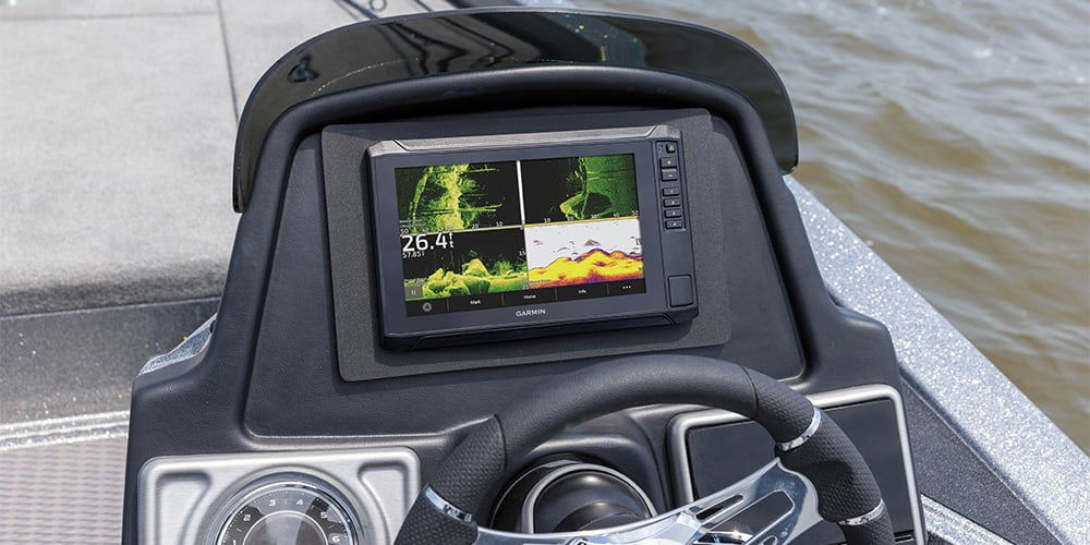
When it comes to fishfinding sonar, recent years have brought remarkable advances in clarity, target separation, imaging range and underwater detail. Modern marine electronics can now reveal structure, baitfish, bottom transitions and suspended fish with an incredible level of precision that would have seemed impossible only a few years ago. But advanced technology is only helpful if you understand what the display is actually showing you — and how to interpret that information to help you locate and catch more fish consistently.
In this article, we’ll take a deeper look at two of the most important modern fishfinding technologies available today: down-scan sonar and side-scan sonar. We’ll explain how scanning sonar works, what makes these technologies different from traditional 2D sonar, how to interpret what you see on screen and how to use scanning sonar effectively in real-world fishing situations.
Whether you fish offshore wrecks, freshwater reservoirs, shallow grass flats, rock piles, docks or deep ledges, understanding scanning sonar can dramatically improve your ability to locate productive structure and identify fish-holding areas faster.
How Scanning Sonar Works
Unlike traditional 2D sonar that produces a broad cone-shaped transmission widening as it travels downward through the water column, both down-view and side-view scanning sonar use extremely thin fan-shaped beams of high-frequency sonar energy. These tightly focused beams concentrate more energy on individual targets and create far more detailed images of underwater structure and fish.
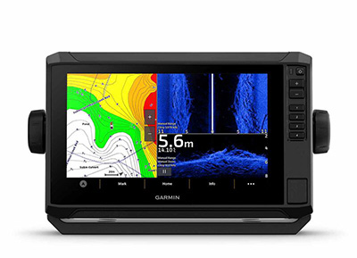
Garmin's ECHOMAP™ UHD2 series allows you to have down-view, side-view and charts on the screen at the same time to make it easier to find your catch.
As the boat moves across the water, these narrow sonar slices are digitally assembled into a flowing historical image showing bottom contour, submerged structure, bait schools and fish targets. Instead of simply showing generic sonar arches and depth readings, scanning sonar creates photo-like images that help anglers visualize the underwater environment much more clearly.
Scanning sonar systems commonly transmit at multiple frequencies. Higher frequencies typically provide sharper image resolution and finer detail at shallower depths, while lower frequencies allow deeper water penetration and broader coverage areas.
These technologies are marketed under various manufacturer-specific names, including Garmin’s ClearVü™ and SideVü™, as well as other brands’ versions like SideScan™, DownScan™, DownVision™ and SideVision™. While the branding differs, the core principles remain similar across platforms.
Modern units such as the Garmin ECHOMAP™ UHD2 series allow anglers to display traditional sonar, down-view sonar, side-view sonar and navigation charts simultaneously on a single screen. This combination gives operators multiple perspectives at once and helps create a more complete understanding of what lies below and around the boat. :contentReference[oaicite:0]{index=0}
Why Scanning Sonar Changed Modern Fishing
Before scanning sonar became widely available, anglers often had to interpret relatively abstract sonar arches and bottom lines using traditional 2D sonar alone. While experienced fishermen became very skilled at reading those returns, scanning sonar dramatically reduced the guesswork.
Now anglers can often identify individual brush piles, standing timber, rock formations, wrecks, weed edges, docks and bait schools visually instead of relying entirely on interpretation and experience.
Traditional 2D Sonar vs. Scanning Sonar
Traditional sonar remains extremely useful because it provides excellent real-time target tracking directly beneath the boat. Fish arches, bait schools and bottom hardness changes can all be monitored continuously as the boat moves.
However, traditional sonar uses wider cone angles that sometimes make it difficult to distinguish individual targets close together. Scanning sonar solves this by narrowing the sonar beam significantly, improving image detail and target separation.
The tradeoff is that scanning sonar behaves more like an imaging system than a continuous real-time sonar cone. This means fish and structure may appear differently than they do on traditional sonar displays.
When Traditional Sonar Still Works Best
Traditional sonar still excels for vertical fishing, deep dropping, jigging and monitoring fish directly beneath the boat in real time. Many serious anglers continue running traditional CHIRP sonar alongside scanning sonar because the technologies complement each other very well.
Running both views simultaneously often provides the best balance of fish identification and structural detail.
Down-View Vs. Side-View Sonar
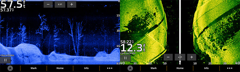
As we’ve suggested, down-view and side-view scanning sonar each offer unique advantages depending on fishing style, depth and the type of structure you’re searching for.
Down-scanning sonar focuses directly beneath the boat and provides highly detailed imagery of bottom composition, submerged structure and fish-holding cover. Side-scanning sonar projects sonar beams outward to both sides of the boat, covering a much larger search area.
Think of down-view sonar as a high-detail inspection tool and side-view sonar as a broad-area search tool.
When to Use Down-View Sonar
Down-view sonar is extremely effective for identifying submerged structure directly beneath the boat. Brush piles, rock piles, wrecks, standing timber, ledges, grass edges and hard-bottom transitions appear with much greater detail than on traditional sonar.
This technology is especially valuable when fishing vertically or targeting precise structure in freshwater lakes, reservoirs, reefs or wreck systems.
When to Use Side-View Sonar
Side-view sonar is designed to search large areas quickly. Instead of scanning only below the boat, it scans outward to the port and starboard sides simultaneously.
This allows anglers to locate structure, bait and fish without driving directly over them. Side-scan is especially useful in shallow water, flats fishing, reservoir fishing and offshore structure hunting.
Know What You're Seeing with the Tech You're Using
Because down-scanning sonar uses an extremely narrow sonar slice, fish targets often appear as dots, streaks or small bright marks instead of the classic arches commonly seen on traditional sonar.
This can initially make fish interpretation more difficult, especially when fish are small or moving quickly through the beam. In many situations, running traditional sonar and down-scan simultaneously provides the best combination of fish detection and environmental detail.
Down-scanning sonar scrolls from right to left on most displays, with the newest information appearing on the right side of the screen first.
Most modern fishfinders also allow operators to adjust color palettes, contrast, gain and filtering options to improve visibility based on water clarity, sunlight conditions and personal preference.
How Fish Appear on Down-Scan Sonar
Suspended fish often appear as small bright dots or tiny streaks separated from structure. Fish holding tightly against bottom structure may be harder to distinguish and sometimes require careful interpretation.
Learning how baitfish schools, predators and bottom structure appear under different conditions takes practice, but scanning sonar dramatically shortens the learning curve compared to older sonar systems.
More about Side-Scan Imaging
Side-scan sonar sends wide sonar beams outward to both sides of the boat, often covering hundreds of feet in total scanning width. This makes it incredibly effective for searching unfamiliar water quickly and locating productive fishing structure.
When the sonar beam strikes submerged objects, those objects create acoustic shadows behind them. These shadows are one of the most important clues in side-scan interpretation because they help reveal object height, shape and separation from the bottom.
The dark center portion of the display represents the water column directly beneath the boat. The sonar images extending outward from the center show the bottom and structure to either side.
Unlike traditional sonar, side-scan images scroll vertically from top to bottom on the display, which can take some adjustment for new users.
How Boat Speed Affects Side-Scan
Boat speed has a major effect on side-scan image quality. Moving too quickly can stretch or distort images, while moving too slowly may reduce coverage efficiency.
Most anglers find moderate, consistent boat speeds produce the clearest side-scan images and the most useful interpretation.
How Side-Scan Helps Locate Fish-Holding Structure
Side-scan excels at locating isolated structure such as brush piles, submerged trees, rock piles, wrecks, ledges, depressions and grass lines.
Once promising structure is identified, anglers often switch to down-view sonar or traditional sonar for closer inspection and precise positioning.
Understanding Sonar Frequencies
Scanning sonar systems commonly allow anglers to choose between different sonar frequencies. Higher frequencies generally create sharper, more detailed images but with reduced range and depth capability.
Lower frequencies provide greater depth penetration and wider coverage but with slightly reduced image detail.
Choosing the proper frequency depends on water depth, target size, bottom composition and the type of fishing being performed.
High Frequency vs. Low Frequency Scanning
- High-frequency sonar: Better detail, shallower water, sharper target separation
- Low-frequency sonar: Greater depth penetration, wider coverage, improved offshore range
How Bottom Composition Appears on Sonar
Different bottom types reflect sonar differently. Hard bottoms such as rock, shell and compact sand often produce stronger, brighter sonar returns.
Softer bottoms like mud or silt generally appear darker and less reflective.
Understanding these differences helps anglers identify productive transition zones where fish commonly feed and hold.
Why Bottom Transitions Matter
Areas where hard and soft bottom meet frequently attract baitfish and predator species because they create changes in current flow, forage concentration and habitat.
Scanning sonar makes these transitions much easier to identify than older sonar technologies.
Common Scanning Sonar Mistakes
- Running sensitivity too high and creating excessive clutter
- Using improper frequency for water depth
- Moving too quickly while scanning
- Ignoring shadow detail in side-scan images
- Expecting down-scan fish arches like traditional sonar
- Failing to learn how structure appears under different conditions
- Not adjusting contrast and palette settings
Why Practice Matters
Like radar and chartplotters, sonar interpretation improves dramatically with experience. Spend time comparing sonar images to known structure, visible docks, reefs and underwater features.
The more time spent interpreting sonar returns, the easier it becomes to distinguish fish, bait, structure and bottom changes quickly and accurately.
How Modern Fishfinders Improve Interpretation
Modern fishfinders now include advanced CHIRP processing, ultra-high-definition imaging, split-screen viewing, waypoint marking, live mapping and advanced filtering tools that help improve sonar interpretation significantly.
Some systems even allow anglers to record sonar logs and review underwater structure later for strategic fishing analysis.
Combined with GPS mapping and waypoint integration, scanning sonar has become one of the most powerful fishfinding technologies available to recreational and professional anglers alike.
Browse All Marine Electronics & Navigation Gear
- Chartplotters, GPS units, radar systems, and integrated navigation displays
- Sonar, CHIRP, downscan, and fish-finding electronics
- Marine stereos, speakers, amplifiers, and audio accessories
- VHF radios, AIS, satellite communication equipment
- Autopilot systems and steering control components
- Wind, depth, speed, and multifunction instruments
- Marine binoculars for navigation and low-light use
- Thermal and night-vision devices for situational awareness
- Onboard monitoring and security systems
- Magnetic and electronic compasses
- Paper and electronic navigation charts
- Regional cruising and harbor guides
- Traditional navigation plotting tools