There’s an app for everything these days and boating is not an exception. These top 5 boating apps give you a ton of information to make your time on the water safer and, most importantly, more fun! We'll walk your through the key features of each.
- For comprehensive nautical charts: Navionics
- For a huge community of boaters and access to custom contour maps: Garmin ActiveCaptain
- For free access to NOAA charts and a ton of premium features at a low monthly cost: iNavX
- For free global ship tracking: MarineTraffic - Ship Tracking
- For free hourly weather forcasts: The Weather Channel
Navionics
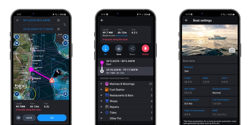
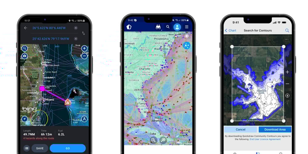
Top features: The Navionics app puts comprehensive nautical charts in the palm of your hand. With SONARCHART™ 0,5 m bathymetry charts, official unaltered NOAA charts and a variety of map overlays including satellite imagery, relief shading and sonar imagery, the Navionics app makes it incredibly easy to chart your route. Plus, with the ability to set your boat size, cruising speed and more, Navionics can estimate your travel time and fuel consumption for any trip.
How much does the Navionics app cost? A year subscription for a given region costs $49.99. The most popular region subscription includes lakes, rivers and coastal marine charts for the U.S. & Canada.
Garmin ActiveCaptain
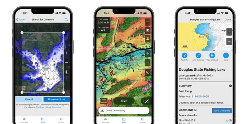
Top features: Garmin's ActiveCaptain app creates a powerful connection between your compatible phone or tablet with your Garmin charplotter, charts and community. The app allows you to access your charts from anywhere, plan trips on your mobile device with custom waypoints and automatically see them on your chartplotter, gives you access to the ActiveCaptain community with tons of expert info from other boaters and more.
How much does the Garmin ActiveCaptain cost? Completely free!
iNavX
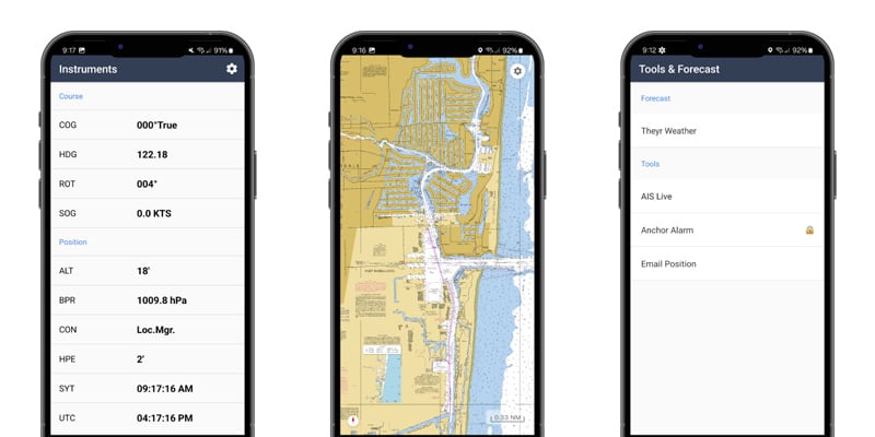
Top features: The iNavX app delivers charts from multiple popular chart providers and hundred of useful features like custom waypoints, routes, voyage tracking, weather forecasts, anchor and AIS alarms, port/navaid searching and more.
How much does the iNavX app cost? The app comes with free access to high resolution NOAA U.S. waters marine charts and a selection of instruments that function off your phone's built-in GPS. iNavX Pro costs $2.50 per month and unlocks customs waypoints and route navigation, voyage tracking, port search, anchor alarm and many other useful features. The iNavX in-app store also features additional chart and subscription options including Theyr Premium, a precision weather & ocean forecast overlay for nautical charts that cost $9.99 when billed monthly or $34.99 annualy which works out to $2.92 per month.
MarineTraffic - Ship Tracking
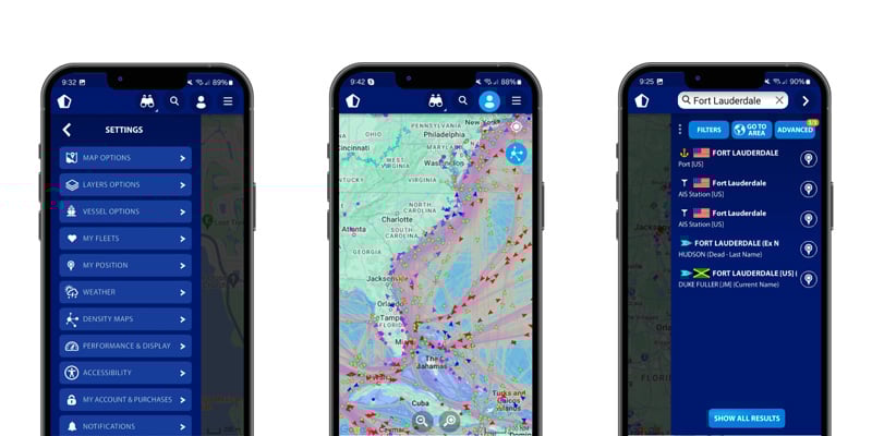
Top features: The MarineTraffic app uses Automatic Identification System (AIS) data to track ships around the world in real time and built-in search functionality makes it easy to find almost any vessel or port in the world. The app also features weather forecasts, density maps, the ability to create and monitor a custom fleet of vessels and more.
How much does the MarineTraffic app cost? The base app is free and provides basic tracking of ships around the world, vessel and port search, and more. The starter plan costs $10.99 per year and comes with a ton of features including an ad-free experience, extended vessel and port details, advanced density maps, weather forecasts, route planning and much more. The app also has the option to add on weather maps and nautical charts for an additional monthly subscription fee.
The Weather Channel
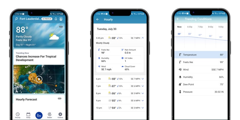
Top features: The Weather Channel app can be a huge help in planning your day on the water. Even though most boatings apps have weather data built in, it doesn’t hurt to double check conditions with another weather forecast to help you avoid unsafe conditions on the weather. The app can also send you push notifications for your area so you have a heads up when conditions will change soon.
How much does The Weather Channel app cost? It’s completely free!
Learn More and Download for iOS >
Learn More and Download for Android >
Need More Help?
West Marine is the perfect place to get ready for any trip. From safety gear to coolers, we have everything you need to have a great day on the water. Find your store here.
Related Articles
Browse All Marine Electronics & Navigation Gear
- Chartplotters, GPS units, radar systems, and integrated navigation displays
- Sonar, CHIRP, downscan, and fish-finding electronics
- Marine stereos, speakers, amplifiers, and audio accessories
- VHF radios, AIS, satellite communication equipment
- Autopilot systems and steering control components
- Wind, depth, speed, and multifunction instruments
- Marine binoculars for navigation and low-light use
- Thermal and night-vision devices for situational awareness
- Onboard monitoring and security systems
- Magnetic and electronic compasses
- Paper and electronic navigation charts
- Regional cruising and harbor guides
- Traditional navigation plotting tools