Stay In Touch with Friends, Family and Emergency Services
Carrying a satellite communication device when you will be out of cell phone range for long periods of time allows you to keep in touch with family and friends or signal for help in an emergency. Models from SPOT and Garmin are small and easy to carry and are popular among hikers, mountain bikers, climbers, boaters and recreational pilots as an easy way to stay prepared for emergencies.
Do You Need an Emergency Beacon or a Tracking and Texting Device?
If your primary use for your new device will be to check in with family or allow them to track your location through GPS coordinates updates then a Satellite Emergency Notification Device (SEND) will work best. A SEND uses commercial satellite systems, rather than the international Cospas-Sarsat satellite system, to transmit GPS location-based distress calls, tracking messages and check in with family. Since SEND devices transmit over commercial satellite systems they require a subscription plan.
If you need an emergency only device then an Emergency Position Indicating Radio Beacon (EPIRB) will work best. An EPIRB is used to alert search and rescue teams in the event of an emergency and broadcasts over the Cospas-Sarsat network which is free to use and does not require a subscription like SEND satellite systems do. EPIRBs are also registered to your vessel so search and rescue teams know what specific vessel they are looking for as soon as the message is sent. The downside to these devices is that they are for emergency use only and do not allow you to send check-in messages to friends and family.
A Personal Locator Beacon (PLB) uses the Cospas-Sarsat system as well but is much smaller than an EPIRB because it is meant to be carried on your person. Since PLBs are handled often it is illegal for them to be automatically activated and require a three-stage activation process to prevent false alarms. They are also registered to the individual owner so they do not require reregistration when you change vessels.
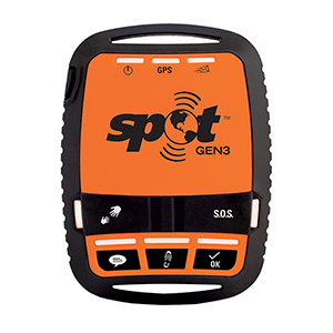
SPOT Gen3 Satellite Messenger
Features vary between models and new features are added often, but SEND devices generally allow you to:
- Send pre-configured messages (“I’m OK,” for example) to a selected group of your contacts.
- Check in and let family and friends track your location using Twitter, Facebook, Google Earth and other web tools.
- GPS Tracking: Create an electronic "breadcrumb trail" for the folks back home, mapping your position at user-selectable intervals ranging from once every 30 seconds to every four hours. In addition to GPS coordinates, track points on some devices also broadcast speed, course and elevation. The Garmin inReach's two-way capability also allows others to "ping" your inReach to see your location and even remotely activate tracking via the Garmin MapShare page. Currently, SPOT's social media platform, SPOT Adventures, has over 88,000 tracked trips from all over the world and users have uploaded over 11,000 pictures to the site.
- Send and receive free-form 160 character text messages. The Garmin inReach devices allow users to send and receive free-form 160 character text messages via the built-in QWERTY keyboard, or by pairing the device to a smartphone or tablet via the "Earthmate" software App.
- Request non-emergency help from your personal contacts.
- Request emergency help, with your information relayed to the appropriate agencies worldwide by a private organization (such as the GEOS International Emergency Response Coordination Center, which is used by SPOT). Hikers, boaters, pilots, and remote workers are just a few examples of SPOT users who have signaled for assistance. When triggering an SOS on two-way messaging capable devices, users receive a delivery confirmation from GEOS and can interact with the search and rescue monitoring center via two-way texting to communicate the nature of the distress and stay in touch throughout the rescue process.
- Purchase costs are lower than an EPIRB but SEND devices generally require a subscription. Subscription plans vary in cost and features.
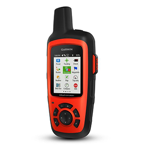
Garmin inReach Explorer+ has two-way messaging, a color screen, plus navigation features.
Outgoing Messages Only
The SPOT Gen3 lets you customize messages on your computer before you leave and send these pre-programmed messages using the Check-in/OK function. You can create custom messages of up to 41 characters plus pre-programmed 120-character messages.. By pushing the "check in" button on the front of the device, your preset message is sent to up to 10 predetermined contacts, but the GEN3 is not capable of receiving messages back from them.
Send Custom Messages and Receive Messages Back
The SPOT X features two way messaging with any cell number or email address from a physical QWERTY keyboard on the device. Devices in the Garmin inReach line offer preset messages and two-way messaging either directly from the device or from your smartphone connected via Bluetooth and Garmin's Earthmate app. Maps, U.S. NOAA charts, and color aerial imagery can be downloaded to your phone through the Earthmate app as well. Both manufacturers require subscription plans to use two-way messaging and information on pricing is available through SPOT and Garmin.
Navigation Features
In addition to messaging, tracking and SOS capabilities, the SPOT X and the models in the inReach line allow you to set waypoints and plan routes. The color screen on the inReach Explorer and SE provide easy-to-follow maps and the built-in digital compass, barometric altimeter and accelerometer sensors provide heading and bearing information, elevation readings, speed and other useful trip statistics. You can plan your routes and waypoints ahead of time using the Garmin Explore portal and share your trip details with family and friends to follow on the private Mapshare webpage. Garmin's Earthmate app also lets you download free topographic maps and U.S NOAA charts to your smartphone or tablet which connects wirelessly with the inReach device for real-time point-to-point navigation.
Geographic Coverage: Continental and Coastal or Worldwide?
SPOT uses the Globalstar satellite system and coverage includes virtually all continents and thousands of miles of offshore areas. See their coverage map at findmespot.com. The inReach device operates using the Iridium satellite constellation which provides seamless coverage worldwide. Take these coverage maps into account when choosing your device. If you frequently travel in areas that the Globalstar system does not cover then an Iridium compatible device is a better option.